
Water monitoring pilot program for pesticides
The Pest Management Regulatory Agency has completed the water monitoring pilot program. Look for information on the Canadian Water Monitoring Program for Pesticides soon.
On this page
- About the pilot program
- Water monitoring sites
- Laboratory analysis
- Explore the results
- Pilot program limitations
- Our partners
About the pilot program
Health Canada's Pest Management Regulatory Agency conducted a pilot monitoring program for 2 years, from April 2022 to March 2024. We worked in collaboration with Environment and Climate Change Canada (ECCC) and Agriculture and Agri-Food Canada (AAFC).
We're using the data we collected to better inform future pesticide re-evaluations and special reviews. Making these data available to the public increases understanding and awareness.
The pilot program served as a model for:
- developing a national-scale program and a water monitoring framework
- expanding partnerships and improving collaboration
Water monitoring sites
Provincial and local partners, including members of Indigenous communities, worked with us and ECCC and AAFC to collect samples.
We collected water samples from 2 types of water sources at various locations across Canada.
Surface water samples from sources such as rivers, streams, wetlands and lakes were collected 2 times a week, when feasible, during the growing season. At some locations, we collected samples throughout the year.
Groundwater samples were collected from public wells in Ontario once in the fall of year 2, and from 4 wells in Prince Edward Island every 2 weeks throughout year 2.
We chose sampling sites for the pilot program that met 1 or more of the following criteria:
- located in high agriculture areas
- easy for our partners to get to
- previously sampled for pesticides or other chemicals
In year 1 (2022 to 2023), data were available for 86 surface water sites.
In year 2 (2023 to 2024), we collected samples from:
- 107 surface water sites
- including 34 sites from year 1
- 81 groundwater sites
Figures 1 and 2 show the locations of the surface water and groundwater sites. The sites are shown together with Canadian agricultural lands, based on AAFC's 2022 annual crop inventory.
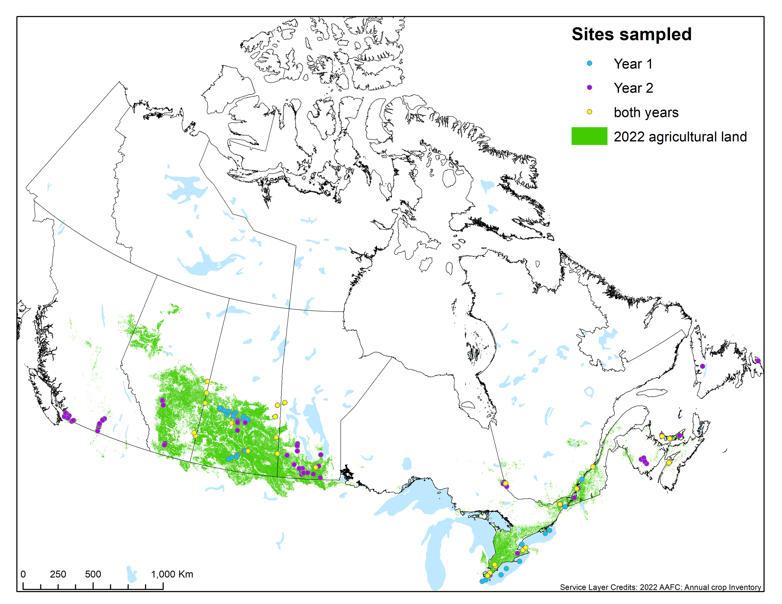
Figure 1 - Text description
This map of Canada shows the location of agricultural lands in 2022 (in green). Most of the lands are in southern Ontario and Quebec and the Prairie provinces.
The dots on the map show the locations of the surface water sites. The 3 colours for the dots correspond to the year that samples were taken.
Blue dots are sites that were only monitored in year 1:
- 1 in British Columbia
- 36 in Saskatchewan
- 14 in Ontario
- 1 in Quebec
Purple dots show the 73 surface water sites that were added in year 2:
- 17 in British Columbia
- 5 in Alberta
- 11 in Saskatchewan
- 20 in Manitoba
- 8 in Ontario
- 3 in Quebec
- 4 in New Brunswick
- 3 in Prince Edward Island
- 2 in Newfoundland and Labrador
Yellow dots show the 34 sites monitored in years 1 and 2:
- 4 in Alberta
- 7 in Saskatchewan
- 2 in Manitoba
- 10 in Ontario
- 4 in Quebec
- 4 in Nova Scotia
- 3 in Prince Edward Island
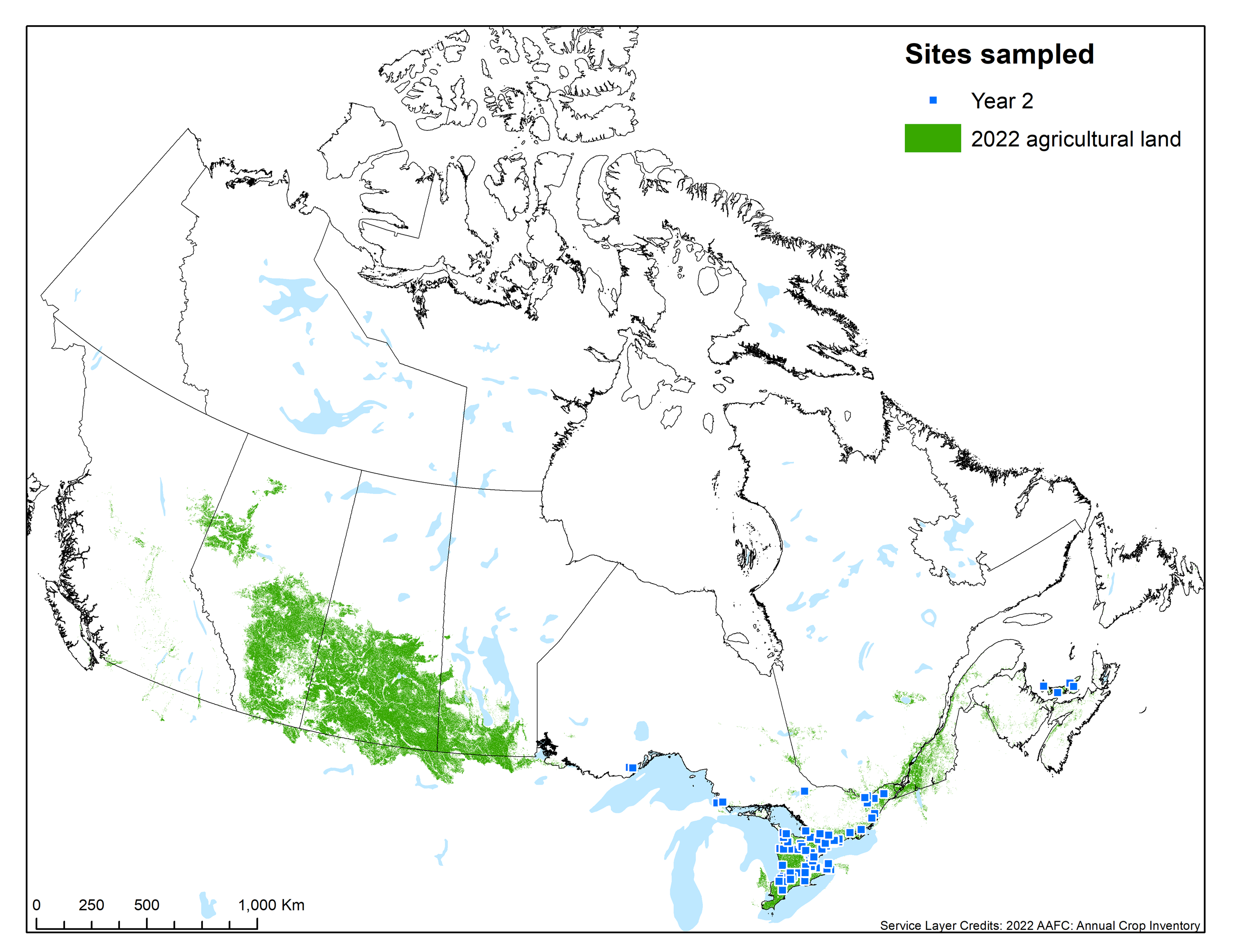
Figure 2 - Text description
This map of Canada shows the location of agricultural lands in 2022 (in green). Most of the lands are in southern Ontario and Quebec and the Prairie provinces.
The blue dots show the groundwater wells monitored in year 2:
- 77 in Ontario
- 4 in Prince Edward Island
Laboratory analysis
Health Canada's pesticide laboratory developed a liquid chromatography method to analyze:
- currently registered pesticides for outdoor use and
- transformation products formed from some of these pesticides
In year 1 of this pilot program, our lab analyzed:
- 185 pesticides
- 2 transformation products
In year 2 of this pilot program, our lab analyzed:
- 188 pesticides
- 2 transformation products
To analyze the increased number of samples collected in year 2, some samples were sent to AAFC's London Research Development Centre laboratory. AAFC's lab analyzed:
- 171 pesticides
- 157 of these pesticides are also analyzed by Health Canada's laboratory
- 3 transformation products
- 2 transformation products are also analyzed by Health Canada's laboratory
We also sent some samples taken in both years to the University of Guelph's Agriculture and Food Laboratory. This lab analyzed the samples for glyphosate, 4 other pesticides and 6 transformation products.
Samples analyzed
In year 1:
- Health Canada analyzed 1,205 samples and posted results to Open Data:
- University of Guelph analyzed 195 of these samples.
In year 2:
- Health Canada posted results for 3,670 samples to Open Data, and of these samples:
- Health Canada analyzed 2,130
- AAFC's lab analyzed 1,540
- University of Guelph analyzed 264
Results from additional samples are not posted to Open Data and include quality control samples, such as blanks, duplicates and interlaboratory samples.
In total, data from 4,875 samples are available on the Open Data portal.
Explore the results
You can check out all results on our Open Data portal.
You'll find information on:
- the pesticides we analyzed
- concentrations of pesticides detected
- other water quality parameters
- such as pH, temperature and conductivity
- the sampling sites
- such as description and location
Also check out our interactive water monitoring for pesticides dashboard for interactive summaries on:
- how often pesticides are detected
- concentrations of pesticides detected
- a comparison of pesticide concentrations to our aquatic life reference values and human health reference values
- data limitations and disclaimer
- check out the "Understanding the Data" tab
Note that a standardized detection limit is used on the dashboard to allow us to compare the results between labs. For this reason, the number of detections calculated with the raw data may not match the dashboard numbers.
Pilot program limitations
There were some program limitations that can affect the interpretation of the results.
Limitations related to site selection
We relied on partners for collecting samples. Working with these partners, we chose sampling sites based on existing water monitoring networks, with an emphasis on those located in agriculture areas. We also considered sites that were sampled for pesticides in other monitoring programs.
Site types included lakes, large rivers, watersheds and small streams next to agricultural lands, and some groundwater wells.
The concentration of chemicals detected in a sample can be affected by a number of factors, such as:
- how close the site is to agricultural lands where pesticides are used
- the size of the water body where the sampling site is located (larger water bodies contain a larger volume of water, which can dilute the concentration of chemicals)
- the properties of the chemical, such as its persistence in the environment
- the amount and timing of any pesticide applications
To select sites for future sampling, we will take a science-based approach, using:
- geospatial tools
- knowledge of pesticide-use areas
- fate characteristics of pesticides
This approach helps us identify areas where there might be a higher risk of pesticides moving to water.
Comparing results to reference values
Groundwater samples are only compared to the human health reference values. This is because groundwater samples are considered drinking water sources for pesticide risk assessments.
Surface water samples, which are used for both human health and environmental risk assessments, can be compared to both human health and aquatic life reference values.
Note: Other jurisdictions have their own benchmarks or reference values, which may be different from ours.
Other pesticide data
In addition to data from this program, pesticide concentrations are available from other sites across Canada.
Here are a few examples of Canadian pesticide data available online:
- Quebec: Water atlas (in French only)
- Prince Edward Island: Monitoring for pesticides in drinking water
- Ontario: Pesticide concentrations in stream water
- Saskatchewan: Primary station water quality
- ECCC: National water quality pesticides surveillance data
Our partners
We owe the success of this program to many partners, including the following federal, provincial, local and Indigenous organizations:
- Health Canada, Regulatory Operations and Enforcement Branch, Pesticide Laboratory
- Environment and Climate Change Canada (ECCC)
- Agriculture and Agri-Food Canada (AAFC)
- Government of New Brunswick
- Government of Newfoundland and Labrador
- Government of Prince Edward Island
- Manitoba Métis Federation
- Swan Lake First Nation
- Essex Region Conservation Authority
- Oldman Watershed Council
- Organisme de bassin versant du Témiscamingue
- Red Deer River Watershed Alliance
- University of Guelph, Laboratory Services, Agriculture & Food Laboratory
Related links
Page details
- Date modified: