Scotch Bonnet Island and Mohawk Island National Wildlife Areas Management Plan: chapter 1
1 Description of the Protected Area
Both Scotch Bonnet Island and Mohawk Island are small, sparsely vegetated islands, with thin soils over solid limestone (Figure 1; Figure 3). These two Great Lakes islands provide important nesting habitat for large numbers and a significant diversity of colonial waterbirds. They are both located within major migratory flyways and provide stopover habitat for many waterfowl and shorebirds during spring and fall migration. Scotch Bonnet Island (1 ha) is located in Lake Ontario, off the western shore of Prince Edward County, Ontario (Figure 2). Mohawk Island (4 ha) is located in eastern Lake Erie, near the town of Dunnville in Haldimand County, Ontario (Figure 4).
The ruins of stone lighthouses built in the 19th century are also present on both islands, and although these are no longer active navigational beacons, they hold historical and cultural significance. The Scotch Bonnet lighthouse, for example, has been identified as one of the last remaining sentinels of the schooner era on Lake Ontario. The two islands were independently established as National Wildlife Areas (NWAs) in the late 1970s, when their lights were no longer necessary for Great Lakes navigation. The islands are managed by Environment and Climate Change Canada’s Canadian Wildlife Service. They are jointly addressed in this management plan because they have similar features and share common management issues.
At the international level, both areas are classified under the International Union for the Conservation of Nature and Natural Resources criteria for protected areas as Category 1A protected areas (Dudley, 2008). They are protected for the conservation of species and genetic diversity, and scientific monitoring and research, and not promoted as a tourism destination or for on-site public education.
| Category | Information |
|---|---|
| Protected area designation | National Wildlife Area |
| Province or territory | Ontario |
| County | Prince Edward |
| Latitude and longitude | Latitude 43°54’00”N Longitude -77°32’25”W |
| Size | 1 ha |
| Protected area selection criteria (Protected Areas Manual) | Criteria 1.a) - “the area supports a population of a species (...) or a group of species which is concentrated for (...) a portion of the year.” For these NWAs: Both islands are important nesting, roosting and loafing sites for large numbers of colonial waterbirds, and a staging area for waterfowl and shorebirds during migration. Criteria 3.a) - “the area is rare or unusual wildlife habitat, of a specific type in a biogeographic region.” For these NWAs: Each island is a significant geographic feature in the Great Lakes, and provides protection to birds from predators and disturbance. |
| Protected area classification system (Protected Areas Manual) | Species or critical habitat conservation |
| International Union for Conservation of Nature and Natural Resources (IUCN) classification | Category 1A, Strict Nature Reserve: “Strictly protected areas set aside to protect biodiversity (…) features, where human visitation, use and impacts are strictly controlled and limited to ensure protection of the conservation values. Such protected areas can serve as indispensable reference areas for scientific research and monitoring” (Dudley, 2008). |
| Order in Council Numbers | P.C. 1979-3017 |
| Directory Federal Real Property (DFRP) Number | 29224 |
| Gazetted | 1979 |
| Additional designations | North American Bird Conservation Initiative (NABCI) Bird Conservation Area 13; within Mixedwood Plains Ecozone, Manitoulin - Lake Simcoe Ecoregion |
| Faunistic and floristic importance | Important colonial waterbird nesting site for many species, including Herring Gull (Larus argentatus), Double-crested Cormorant (Phalacrocorax auritus), Black-crowned Night Heron (Nycticorax nycticorax), Great Black-backed Gull (Larus marinus), Caspian Tern (Hydroprogne caspia), and occasionally Common Tern (Sterna hirundo). Loafing, foraging and stopover site for migrating waterfowl and shorebirds during spring and fall migration. |
| Invasive species | None recorded |
| Species at risk | None recorded |
| Management agency | Environment and Climate Change Canada - Canadian Wildlife Service (Ontario) |
| Public access and use | Public access is prohibited year round, except by Canada Wildlife Act (CWA) permit, for research and to monitor and maintain infrastructure. Recreational use limited to offshore and nearshore areas. Boating and wildlife viewing in the nearshore are discouraged during the breeding season (between April and August) because activities may cause colonial nesting waterbirds to abandon nests. |
| Others | There are no docking or access facilities at either site. The shoreline is rocky; all authorized visitors should exercise caution. |
| Protected area designation | National Wildlife Area |
| Province or territory | Ontario |
| County | Haldimand |
| Latitude and longitude | Latitude 42°50'05"N Longitude -79°31'22"W |
| Size | 4 ha |
| Protected area selection criteria (Protected Areas Manual) | Criteria 1.a) - “the area supports a population of a species (...) or a group of species which is concentrated for (...) a portion of the year.” For these NWAs: Both islands are important nesting, roosting and loafing sites for large numbers of colonial waterbirds, and a staging area for waterfowl and shorebirds during migration. Criteria 3.a) - “the area is rare or unusual wildlife habitat, of a specific type in a biogeographic region.” For these NWAs: Each island is a significant geographic feature in the Great Lakes, and provides protection to birds from predators and disturbance. |
| Protected area classification system (Protected Areas Manual) | Species or critical habitat conservation |
| International Union for Conservation of Nature and Natural Resources (IUCN) classification | Category 1A, Strict Nature Reserve: “Strictly protected areas set aside to protect biodiversity (…) features, where human visitation, use and impacts are strictly controlled and limited to ensure protection of the conservation values. Such protected areas can serve as indispensable reference areas for scientific research and monitoring” (Dudley, 2008). |
| Order in Council Numbers | P.C. 1978-1439 |
| Directory Federal Real Property (DFRP) Number | 10447 |
| Gazetted | 1978 |
| Additional designations | North American Bird Conservation Initiative (NABCI) Bird Conservation Area 13; within Mixedwood Plains Ecozone, Lake Erie Lowland Ecoregion |
| Faunistic and floristic importance | Important colonial waterbird nesting site for many species, including Ring-billed Gull (Larus delawarensis), Herring Gull, Double-crested Cormorant, Caspian Tern, and occasionally Common Tern and Great Black-Backed Gull. Loafing, foraging and stopover site for migrating waterfowl and some shorebirds during spring and fall migration. |
| Invasive species | Zebra Mussel (Dreissena polymorpha) and Quagga Mussel (Dreissena rostriformis bugensis) shells, Purple Loosestrife (Lythrum salicaria), Mute Swan (Cygnus olor) |
| Species at risk | None recorded |
| Management agency | Environment and Climate Change Canada - Canadian Wildlife Service (Ontario) |
| Public access and use | Public access is prohibited between April 1 and August 31 except by CWA permit for research and to monitor and maintain infrastructure. Public access to NWA for day use allowed only between September 1 and March 31, from sunrise to sunset. Activities allowed at the island during this period include wildlife viewing, picnicking, recreational fishing from shore (no lead sinkers and spears), swimming, and boat landing (motorized and non-motorized boats). Overnight camping and open fires are prohibited at all times. Boating and wildlife viewing in the nearshore are discouraged during the breeding season (between April and August) because activities may cause colonial nesting waterbirds to abandon nests. |
| Others | There are no docking or access facilities at either site. The shoreline is rocky; all authorized visitors should exercise caution. |
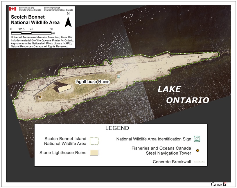
Long description for figure 1
Aerial photograph of Scotch Bonnet Island in Lake Ontario with additional features representing the boundaries of the National Wildlife Area (NWA) and the location of the stone lighthouse ruins, the NWA identification sign, the Fisheries and Oceans Canada steel navigation tower and the concrete breakwall. The photograph and its features are expressed in metres.
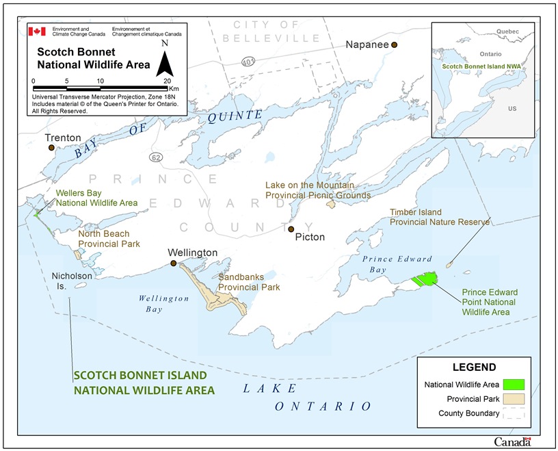
Long description for figure 2
Maps of Scotch Bonnet Island National Wildlife Area (NWA) in relation to the province of Ontario (inset map) and in relation to Prince Edward County, Eastern Ontario, in Lake Ontario (main map). The inset map indicates that the NWA is located in southeastern Ontario. The main map represents in more detail the boundaries and location in Prince Edward County of Scotch Bonnet Island, Wellers Bay and Prince Edward Point NWAs, North Beach, Sandbanks and Timber Island provincial parks, and Lake on the Mountain provincial picnic grounds. The map scale is expressed in metres.
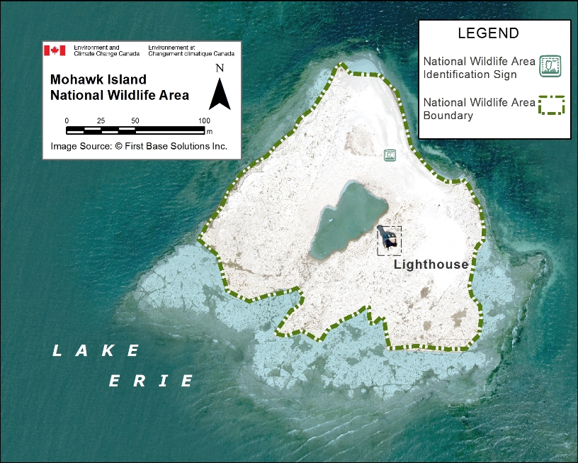
Long description for figure 3
Aerial photograph of Mohawk Island in Lake Erie. The boundaries of the National Wildlife Area, an identification sign and a lighthouse are all outlined. There is a small water hole in the centre of the island. The photograph and its features are expressed in metres.
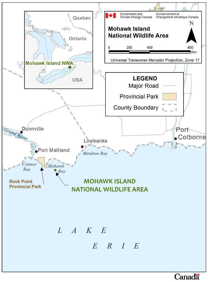
Long description for figure 4
Maps of Mohawk Island National Wildlife Area (NWA) in relation to the province of Ontario, Quebec and the USA (inset map) and in relation to the eastern basin of Lake Erie, Ontario (main map). The main map outlines in more detail the boundaries of the NWA and Rock Point Provincial Park, and the closest towns and main roads. The map scale is expressed in km.
1.1 Regional context
Scotch Bonnet Island NWA is found within Lake Ontario, located approximately 20 km due south of the town of Trenton, in Prince Edward County. The mainland portion of the county is effectively a large (700 km2) peninsula, with over 800 km of shoreline largely surrounded by Lake Ontario and the Bay of Quinte (Figure 2). The island is named after one of three north-south trending rises of glacio-lacustrine clay and till, known as the Scotch Bonnet Ridge, in eastern Lake Ontario.
Scotch Bonnet Island and surrounding region are located within the Mixedwood Plains Ecozone and the Manitoulin-Lake Simcoe Ecoregion (Ecological Stratification Work Group, 1995). The climate within this ecozone is strongly influenced by the large open waters of the Great Lakes, commonly referred to as the “lake effect,” in which the lakes have a moderating effect on air temperatures. Precipitation is uniformly distributed throughout the seasons, although there can be great variation in day-to-day weather.
The predominant land use in Prince Edward County is agriculture, and it is also a popular tourist destination for recreational fishing and boating. There is also commercial fishing (trap net and gill net) in the surrounding waters. Prince Edward County contains many natural areas, including provincial parks (Presqu’ile, North Beach, Sandbanks, Lake on the Mountain and Timber Island) and wildlife management areas (Point Petre Provincial Wildlife Management Area), and federal protected areas (Wellers Bay NWA and Prince Edward Point NWA) (Figure 2). The Prince Edward County South Shore Important Bird Area is located southeast of the Scotch Bonnet Island NWA. The entire region is important during migration: over 300 species of birds, primarily songbirds and raptors, move through Prince Edward County along the Atlantic Flyway during the spring and fall.
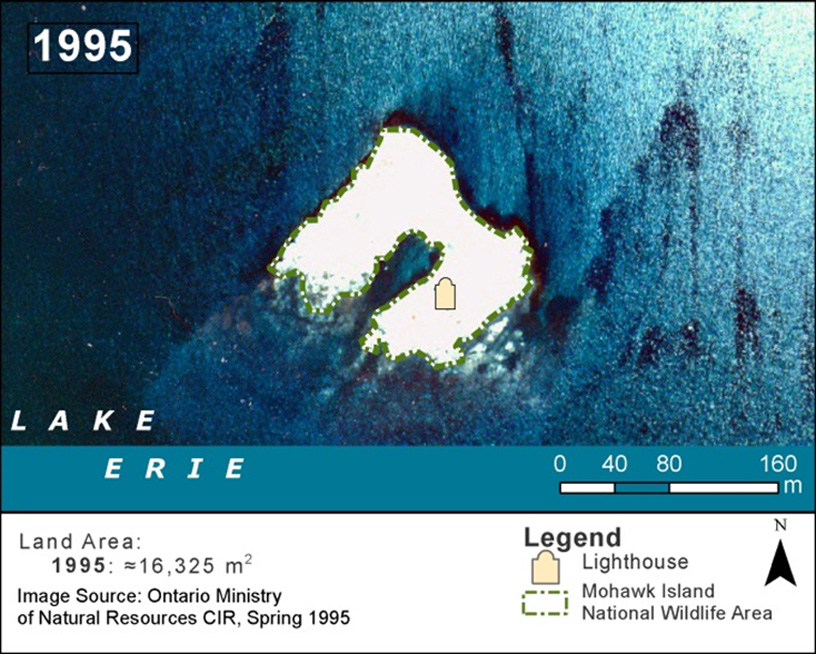
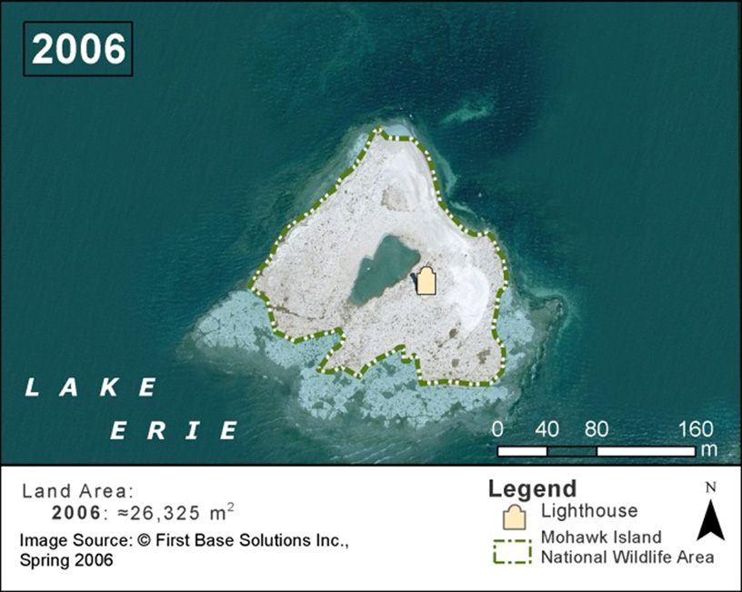
To the west, Mohawk Island NWA is located in the eastern basin of Lake Erie, approximately 20 km southwest of Port Colborne, near the mouth of the Grand River (Figure 4). Limestone outcroppings have created reefs and small islands in these relatively deep waters for Lake Erie, and Mohawk Island is the largest of the islands in the area. The above-water area of Mohawk Island fluctuates with the levels of Lake Erie. For example, in 1995 the land area of Mohawk Island was approximately 16 325 m2. In 2006, when water levels were lower (than 1995), the exposed land area was approximately 26 325 m2 (Figure 5).
Like Scotch Bonnet Island, the area's climate is moderated by the Great Lakes, with the lake acting as a heat reservoir. In spring, air is cooled as surface waters remain near freezing. During fall and winter, the water warms the air, and fog occurs frequently. Lake Erie water levels also fluctuate over a range of about 4 m, with annual fluctuations generally ranging from 1 to 2 m (Fisheries and Oceans Canada, 2010). During severe storms, which occur most often in November, this can create waves 2 to 5 m high, sometimes higher than Mohawk Island itself.
Long description for figure 5
Aerial photographs of Mohawk Island and its above-water land area in 1995 (first photograph) and 2006 (second photograph). Both photographs depict the boundaries of the National Wildlife Area and the location of the lighthouse. The second photograph has an increase in land mass. The photograph and its features are expressed in metres.
To the north of Mohawk Island, the predominant land use on the mainland in Haldimand County is agriculture. There is also an active commercial fishery in this part of the Great Lakes. In the surrounding areas, there are a few natural areas remaining, such as Rock Point and James N. Allan Provincial Parks, Dunnville Marshes, and Byng Island Conservation Area along the Grand River. The northern shoreline of Lake Erie--including Mohawk Bay, Rockhouse Point, Port Colborne and Port Maitland (at the mouth of the Grand River)--is known for large numbers of migrating birds during spring and fall. The Rock Point Banding Station, located in Rock Point Provincial Park, is a Canadian Migration Monitoring Network station operated by the Haldimand Bird Observatory. Terns, gulls and cormorants are often observed feeding along the Lake Erie shoreline. Many species of waterfowl and shorebirds pass through and use the islands and surrounding region as a stopover site when crossing Lake Erie along the Mississippi and Atlantic Flyways during spring and fall migration.
1.2 Historical background
1.2.1 History of Scotch Bonnet Island
Scotch Bonnet Island has been a navigational landmark in eastern Lake Ontario since 1856, when the Department of Transport established a navigation aid station on the island. A circular limestone lighthouse 16.5 m high and a lightkeeper’s house were erected on the island to signal the reef to travelling ships, and a foghorn was operated manually. The lightkeeper’s house was vacated in 1924, but the lighthouse continued to operate almost continuously until 1959, when a steel navigation tower with an automatic light replaced the old lighthouse. By the mid-1970s, the old limestone lighthouse had deteriorated, and the Department of Transport declared the island to be excess Crown lands.
The Department of Transport transferred ownership of Scotch Bonnet Island to the Canadian Wildlife Service on March 8, 1979 (P.C. 1979-686), and on November 8, 1979, it was named the Scotch Bonnet Island National Wildlife Area. The primary purpose of establishing the Scotch Bonnet Island NWA was to protect nesting habitat for colonial waterbirds, and to conduct research.
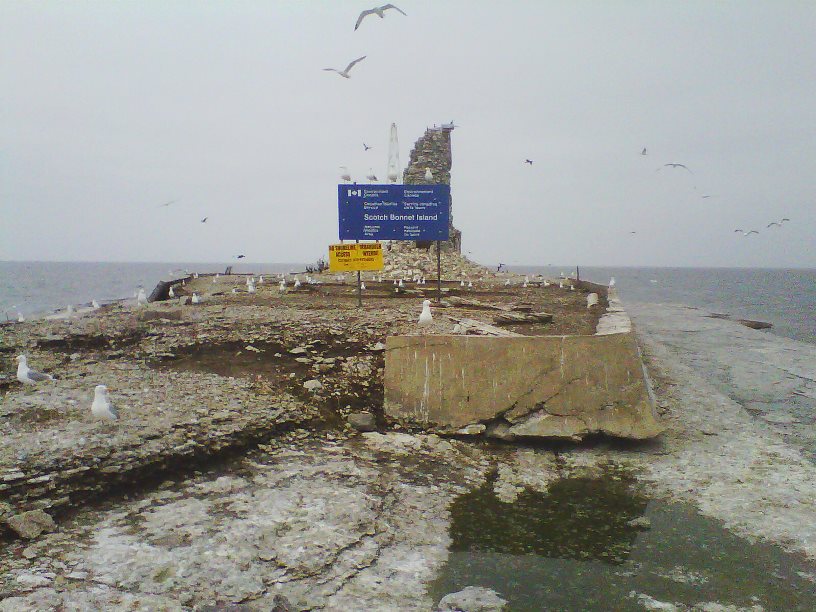
In the conditions of the 1979 land transfer, Transport Canada retained ownership of the steel navigation tower and certain rights to access the steel tower for maintenance, and Parks Canada Agency retained rights to access the stone lighthouse for heritage conservation purposes. The steel navigation tower is currently maintained and operated by Fisheries and Oceans Canada. Today, only partial walls of the stone light tower and house remain and entry to the structure is prohibited (Figure 6)
Long description for figure 6
Photograph of the crumbling remnants of the lighthouse and steel navigation tower, and an identification signboard on Scotch Bonnet Island National Wildlife Area in 2012. A number of gulls are in flight and some are standing on the rocky island.
1.2.2 History of Mohawk Island
The Mohawk Island lighthouse represents an important chapter in Lake Erie's navigational and shipping history. The stone tower, then known as the Gull Island light, and the adjoining stone lightkeeper’s house were built between 1846 and 1848. The light served as a navigational aid to ships entering the southern entrance of the original Welland Canal at Port Maitland, and to warn of the hazardous shoal off the southeast shore of Mohawk Island. The circular stone tower once stood over 18 m high and held an octagonal iron lantern, surmounted by a cupola. Oil lamps with reflectors produced a beam with a range of about 16 km (Planck and Robinson, 1985).
In 1911, the Ontario Department of Lands, Forests and Mines recommended that ownership of Mohawk Island (then known as Gull Island) be transferred to the federal Department of Marine and Fisheries (now Transport Canada) in order to maintain the lighthouse. The light was automated in 1933 using a battery-powered light. When the entrance to the Welland Canal was moved to Port Colborne in 1934, the Mohawk Island light became less important to mariners. Deterioration of the structure continued, and it was gutted by fire in 1969. In 1969 the stone lighthouse was decommissioned and a navigation buoy was placed off the southeast shore of the island to mark the hazardous shoal.
Canadian Wildlife Service biologists examined the island in the early 1970s and proposed that it be designated as an NWA to protect colonial waterbirds. In 1976, the Department of Transport (Transport Canada) transferred control of the island to the Canadian Wildlife Service, now a division of Environment and Climate Change Canada. In 1978, Mohawk Island was formally recognized as an NWA under the Wildlife Area Regulations of the Canada Wildlife Act. A 1977 demolition order was issued by the Department of Transport on the basis that the lighthouse constituted a public hazard, but significant local support delayed the demolition until it was stopped. Today, only the exterior walls of the tower and house remain and entry to the structure is prohibited (Figure 7).

Long description for figure 7
Photograph of the stony lighthouse on Mohawk Island National Wildlife Area in 2007 with multiple birds in flight, a sandy terrain foreground and Lake Erie in the background.
The long-term significance of both islands for colonial waterbirds is well documented. Records of nesting birds at Scotch Bonnet Island date back to the 1930s. Records of nesting birds at Mohawk Island date to the 1890s, as noted in Thomas McIlwraith’s Birds of Ontario (1984). In this same book, McIlwraith also refers to Mohawk Island as “Gull Island”.
Mohawk Island continued to attract birders through the 1930s and 1940s, when significant numbers of gulls and terns were reported (Mitchell, 1946; Gamble, 1948).
This 2013 Scotch Bonnet Island and Mohawk Island National Wildlife Areas Management Plan is an update of the Management Plan: Scotch Bonnet Island National Wildlife Area (Lévesque 1986) and the Management Plan: Mohawk Island National Wildlife Area (Planck and Robinson, 1985) and replaces all other versions.
1.3 Land ownership
Both Scotch Bonnet Island NWA and Mohawk Island NWA are owned by the Government of Canada and are administered by Environment and Climate Change Canada’s Canadian Wildlife Service. Property transfer documents only refer to the term “island,” so it is inferred that Environment and Climate Change Canada owns to the water’s edge of both NWAs. Parks Canada Agency and Fisheries and Oceans Canada (formely Transport Canada maintain access rights to Scotch Bonnet Island NWA, as a condition of the 1979 land transfer.
The Great Lakes are bi-national and are managed jointly by Canada and the United States. Other federal or provincial agencies (Fisheries and Oceans Canada, Ontario Ministry of Natural Resources and Forestry, and Ontario Ministry of the Environment) may be responsible for issuing permits, depending on the type of activity.
1.4 Facilities and infrastructure
Both islands are accessible only by boat. There are no roads, trails or docking facilities at either NWA. Signage is posted to indicate access restrictions, i.e., no access at Scotch Bonnet Island NWA, limited access (September 1 to March 31) at Mohawk Island NWA. Signs can be difficult to install in the bedrock and require frequent maintenance due to damage from the elements.
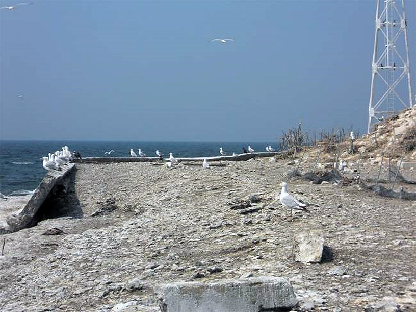
The lighthouses no longer function, and navigational aids mark the islands and shoals for mariners. A steel navigation tower holding an automatic light is located on the west end of Scotch Bonnet Island (Figure 8a, b). At Mohawk Island NWA, there is a navigational buoy in Lake Erie, to the southeast of the island. Both navigation aids are currently owned and operated by Fisheries and Oceans Canada.
Both islands contain the ruins of 19th-century stone lighthouses and associated structures. The Scotch Bonnet Island lighthouse has been showing signs of deterioration for several decades (Figure 8b). In the mid-1980s, Parks Canada Agency staff visited the island to document the architectural heritage of the stone lighthouse. The lighthouse continues to deteriorate, and the ruins pose a safety hazard. Public access to the NWA and entry to the ruins are prohibited.
In the centre portion of Scotch Bonnet Island, a solid concrete breakwall filled with soil brought in from nearby Nicholson Island surrounds the old stone lighthouse and newer steel navigation tower. The breakwall was originally constructed to protect the lighthouse from storms and waves, and it continues to provide protection to the steel navigation tower. However, sections of the breakwall have eroded and have been subject to vandalism such as graffiti (Figure 8a, 8b).
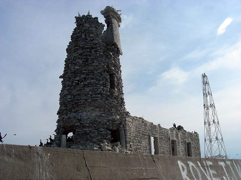
Long description for figure 8
Figure 8a: Photograph of the concrete breakwall deterioration along the south shore of Scotch Bonnet Island National Wildlife Area in 2010. There are a dozen gulls standing on the rocky terrain of the island.
Figure 8b: Photograph of the crumbling lighthouse and concrete breakwall (with graffiti) on Scotch Bonnet Island National Wildlife Area in 2008. A number of gulls are resting on the crumbling lighthouse and breakwall.
The Mohawk Island lighthouse, located on the south side of the island, became unoccupied much earlier, and was vandalized as early as 1938. The lighthouse has been damaged over the years by weather and vandalism, and the exterior walls of the tower and house are all that remain of the original structure (Figure 7). Public access and entry to the lighthouse ruins are prohibited. The structure still serves as an informal navigation landmark for fishing and pleasure boats.
| Type of asset | Approximate size | Responsibility |
|---|---|---|
| NWA signs | 1.2 m × 1.2 m | Environment and Climate Change Canada - Canadian Wildlife Service |
| Steel navigation tower | 19.2 m | Fisheries and Oceans Canada |
| Concrete breakwall | 82 m long × 22 m wide | Environment and Climate Change Canada - Canadian Wildlife Service/Fisheries and Oceans Canada |
| Stone lighthouse | 16.5 m high | Environment and Climate Change Canada - Canadian Wildlife Service/Parks Canada Agency |
| Type of asset | Approximate size | Responsibility |
|---|---|---|
| NWA signs | 1.2 m × 1.2 m | Environment and Climate Change Canada - Canadian Wildlife Service |
| Stone lighthouse | Building footprint = 100 m2, tower 18 m high | Environment and Climate Change Canada - Canadian Wildlife Service |
Page details
- Date modified: