
Mississippi Lake National Wildlife Area Management Plan: chapter 1
1. Description of the Protected Area
The Mississippi Lake National Wildlife Area (NWA) (264 ha) is located at the southwestern end of Mississippi Lake within the Township of Drummond/North Elmsley (formerly Township of Drummond), in eastern Ontario (Figure 1). The Mississippi Lake NWA is located within the boundaries of the Mississippi Lake Migratory Bird Sanctuary (MBS), which is larger in size (Figure 2). The 284 ha Mississippi Lake MBS boundary extends beyond the NWA boundary approximately 75 to 300 m, into the Mississippi Lake and Mississippi River, and includes private land (north of Anchor Point) and water adjacent to the NWA on the Mississippi River (Figure 2). Nearby urban centres include Innisville 0.5 km west, Carleton Place, 20 km northeast, and Perth, 20 km south of the NWA (Figure 1).
The Mississippi Lake NWA is comprised primarily of a large emergent marsh, shrub swamp thicket and shallow open water, and includes McEwen Bay (also known as Mud Lake) in its entirety, along with some drier upland deciduous forest habitat on the north and west boundaries, and old field (former agriculture) and meadow, southwest of McEwen Bay (Figure 2). The small portion of the NWA, along the north shore of the Mississippi River, contains a mixture of marsh, swamp and upland deciduous forest (Figure 2).
A small stream, McIntyre Creek, passes through the southeast corner of the NWA and connects McCoy’s Creek and McEwen Bay to Mississippi Lake (Figure 2). In years of high water levels, the bay may also be connected to the lake for a short distance along the eastern boundary of the NWA north of Anchor Point (Figure 2).
| Summary information | Description |
|---|---|
| Protected Area designation | National Wildlife Area |
| Province or territory | Ontario |
| Geographic township and county | Township of Drummond/North Elmsley (formerly Drummond), Lanark County |
| Latitude and longitude | 45°03' N and 76°14' W |
| Size | 264 ha (249 ha gazetted; 15 ha ungazetted) |
| Environment Canada protected area selection criteria (Protected Areas manual) | Criteria 1. a) - The area supports a population of species or subspecies or a group of species which is concentrated, for any portion of the year. For this NWA: The area is a staging area for migratory waterfowl during spring and fall migration. |
| Environment Canada protected area classification system (Protected Areas manual) | Species or critical habitat conservation |
| International Union for Conservation of Nature (IUCN) classification | Category IV Habitat/species management area: Category IV provides a management approach used in areas that have already undergone substantial modification, necessitating protection of remaining fragments, with or without intervention (Dudley, 2008). |
| Order in council numbers | P.C. 1977-2958 |
| Directory of Federal Real Property (DFRP) number | 09393 |
| Gazetted | 1977 |
| Management agency | Environment Canada - Canadian Wildlife Service (Ontario) |
| Additional designations |
|
| Faunistic and floristic importance |
|
| Species at Risk |
|
| Non-native and invasive species | Purple Loosestrife (Lythrum salicaria), Flowering-rush (Butomus umbellatus), European Frogbit (Hydrocharis morsus-ranae), Eurasian Milfoil (Myriophyllum spicatum L.), Common Buckthorn (Rhamnus cathartica), Tartarian Honeysuckle (Lonicera tatarica), Scots Pine (Pinus sylvestris), Common Lilac (Syringa vulgaris), Double-crested Cormorant (Phalacrocorax auritus), Zebra Mussel (Dreissena polymorpha), Earthworm (undetermined species) and Butternut canker (Ophiognomonia clavigignenti-juglandacearum). |
| Public access and use | Mississippi Lake NWA
Mississippi Lake MBSPossession of firearms and hunting are not permitted within the boundary of the MBS in accordance with the Migratory Bird Sanctuary Regulations, and the Migratory Birds Convention Act, 1994. |
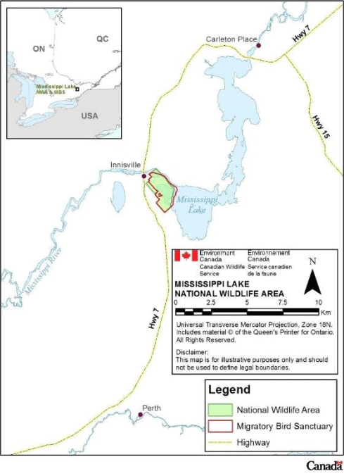
Long description for figure 1
Map of the location of Mississippi Lake NWA in relation to Ontario. Nearby features are the locations of Mississippi Lake MBS, Mississippi Lake and Mississippi River, the towns of Innisville, Carleton Place and Perth, and Highways 7 and 15. Map scale is in kilometres.

Long description for figure 2
Aerial (satellite) photo of the boundaries of Mississippi Lake NWA within Mississippi Lake and overlapping MacEwen Bay and the Mississippi River; other features are McIntyre Creek, the boundaries of the MBS, NWA sign, parking lot, boat launch and washroom. Map scale is in tenths of a kilometre.
1.1 Regional context
The Mississippi Lake NWA is located at the southwest end of Mississippi Lake. Mississippi Lake is one of numerous lakes along the Mississippi River and is one of the largest inland lakes in eastern Ontario. It is the last lake along the Mississippi River before it joins the Ottawa River. The entire perimeter of the lake is 55.9 km, and it reaches a depth of 9.2 m at its deepest point. Mississippi Lake is a mesotrophic lake due to nutrient inputs from development along the shore of the lake (Mississippi Valley Conservation Authority [MVCA], 2008).
Water levels on Mississippi Lake and River and McEwen Bay are controlled by a dam at Carleton Place (Mississippi River Water Management Plan [MRWMP], 2006). The dam is owned by MVCA in co-operation with the town of Carleton Place and Ontario Ministry of Natural Resources (OMNR) and operated following the Mississippi River Water Management Plan (Mountenay, personal communication, 2012). The lake level is managed to achieve an elevation of 134.35 m (MRWMP, 2006). In the fall, the dam is operated to drawdown water levels in Mississippi Lake to provide storage for spring runoff (MRWMP, 2006).
Mississippi Lake is important to the local community. The lake provides the water supply for the town of Carleton Place and is popular for boating and sport fishing, waterfowl hunting, cottaging, and tourism. A number of fishing tournaments, including several professional bass competitions are held annually in Mississippi Lake (MVCA, 2011). In the winter, snowmobiling and ice fishing take place on Mississippi Lake.
In the mid-1980s, approximately 1700 residential structures were reported along the shores of Mississippi Lake, including 16 resorts, 1498 cottages and 259 permanent year-round residences (MVCA, 2011). Since this time, there has been a significant intensification and increase in both the number of residential structures on the lake and conversion of cottages to year-round residences (Symon, personal communication, 2012). McEwen Bay (within the NWA) is one of the few sections of the Mississippi Lake shoreline that is not developed, and the boat launch in the NWA provides the only public access at the southern end of the lake.
The Official Plan for the Township of Drummond/North Elmsley designates the NWA as an Area of Natural and Scientific Interest (ANSI) and as a Provincially Significant Wetland as classified by the Ontario Ministry of Natural Resources (Delcan Corporation, 2012). Surrounding areas are designated as rural.
The MVCA has established a Watershed Watch Program for the Mississippi watershed to monitor water quality and is currently working with OMNR and other organizations to prepare a Mississippi Lake Management Plan in response to increasing concern over development pressure, changes in land use, potential effects of upstream activities and the potential effects of climate change (MVCA 2008; Symon, personal communication, 2012).
The land cover surrounding the NWA is comprised of active and retired farmland (primarily livestock) and old field with numerous wetlands and forests adjacent to the Mississippi Lake and River. The wetlands with the NWA and several wetlands nearby are provincially significant. The “Innisville Wetlands” Provincially Significant Life Science Area of Natural and Scientific Interest (ANSI) is approximately 1900 ha of marsh and swamp and includes Haley and Steward Lakes, and the McEwen Bay provincially significant wetlands, Scotch Corner’s Wetland and Campbell’s Creek Wetlands (Thompson, personal communication, 2012). The size, substrate and habitat diversity make these wetlands some of the best examples of wetland complexes in Eastern Ontario (OMNR, 2012; White, 1992).
The Mississippi Lake NWA and MBS are within the North American Bird Conservation Initiative (NABCI), Bird Conservation Region (BCR) 13; within the Mixedwood Plains Ecozone, Great Lakes - St. Lawrence Forest Region Ecoregion.
The Mississippi Lake NWA is within the geographic area of a number of natural heritage conservation and land stewardship initiatives including the “Lower Great Lakes and St. Lawrence River Area of Continental Significance” under the Eastern Habitat Joint Venture (EHJV) of the Canada-United States-Mexico North American Waterfowl Management Plan (NAWMP, 2012), the Eastern Ontario Model Forest (EMOF, 2010), the Mississippi Madawaska Land Trust Conservancy (MLTC, 2010) and the “Algonquin to Adirondack Initiative” (A2A, 2013).
1.2 Historical background
The Anishinabe Algonquins lived in the area, prior to the arrival of European settlers in the late 1700s. Around 1815, settlers of British origin arrived in the area, and much of the land surrounding Mississippi Lake was cleared for farming and lumber. In 1890, a dam was constructed at Carleton Place. Land at the southwest end of Mississippi Lake was inundated by water, forming Mud Lake (known today as McEwen Bay). The original purpose of the dam was to raise water levels so that timber could be floated downstream, three to four times a year (MVCA, 2011). Local use of Mississippi and Mud Lakes and the surrounding area in the 1800s-1900s included fishing, hunting, recreational boating, trapping of Common Muskrat (Ondatra zibethicus) and American Beaver (Castor canadensis), Wild Rice (Zizania aquatica) harvesting, agriculture (grazing), and maple syrup production (Lévesque, 1986). After construction of the dam, Mud Lake attracted large numbers of waterfowl and became an important hunting area. Prior to the 1890s, the majority of hunting areas were found on the eastern end of Mississippi Lake.
Establishment of the Mississippi Lake MBS
In the 1950s, the Mississippi Fish and Game Protective Association and local landowners advocated for the area to be declared MBS to restrict hunting and provide refuge for staging waterfowl. In 1959, the area was declared a federal bird sanctuary under the Migratory Birds Convention Act (1917). The Mud Lake MBS was renamed Mississippi Lake MBS in 1970 to distinguish it from other Mud Lakes in Ontario. The 284-ha Mississippi Lake MBS includes McEwen Bay, private land surrounding the bay and north of Anchor Point, and a portion of the Mississippi River, east of the town of Innisville (Figure 2). At the same time, McIntyre Creek was also designated as a Provincial Fish Sanctuary by OMNR. The Fish Sanctuary designation was revoked in 1986 to allow sport fishing.
Establishment of the Mississippi Lake NWA
In 1968, the Canadian Wildlife Service (part of the Department of Indian Affairs and Northern Development at that time and subsequently part of Environment Canada in 1978) began purchasing land within the MBS to prevent development and establish a permanent waterfowl sanctuary. The Mississippi Lake NWA (249 ha) was officially designated in 1977 under the Canada Wildlife Act (1973) to protect habitat and create a refuge for staging migratory waterfowl. Mississippi Lake NWA was the first NWA established in Ontario. Since 1977, two small parcels of land (west of McEwen Bay adjacent to the NWA) totalling 15 ha have been acquired by Environment Canada Canadian Wildlife Service (EC-CWS) and are planned for gazetting and management as part of the Mississippi Lake NWA. The Mississippi Lake NWA is 264 hectares in total: 249 gazetted, and 15 ha ungazetted.
1.3 Land ownership
The Mississippi Lake NWA is owned by the Government of Canada and administered by EC-CWS as described in Schedule 1 of the Wildlife Area Regulations of the Canada Wildlife Act. The NWA property is contiguous and is comprised of McEwen Bay in its entirety, land surrounding the bay, a portion of the Mississippi River and a small parcel of land along the north shore of the river (Figure 2). EC-CWS has full ownership of the land below the water in McEwen Bay and regulates activities in the waters proper. The land below and water in the Mississippi River and Mississippi Lake are under the jurisdiction of the Provincial Crown. The federal government does not hold the sub-surface mineral rights for Mississippi Lake NWA.
EC-CWS owns and maintains infrastructure (For example, parking lot, washroom, metal storage container, trail, boat launch and fences) within the Mississippi Lake NWA. Fences installed along NWA boundaries adjacent to private property are jointly owned, and responsibilities for management are shared (see Section 1.4; Table 2).
There are two municipal roads along the NWA boundaries: Drummond Concession 10B and 9A (Figure 2). There are two unopened municipal road allowances within the NWA. These unopened road allowances are not maintained by the municipality and are used infrequently by Environment Canada staff to access the NWA. Public access to the NWA from unopened road allowances is only allowed for foot traffic from December 16 to September 14.
Land adjacent to the NWA is predominantly active and retired farmland under private ownership.
Nothing in this management plan shall be construed so as to abrogate or derogate from the protection provided for existing Aboriginal or treaty rights of the Aboriginal peoples of Canada by the recognition and affirmation of those rights in section 35 of the Constitution Act, 1982.
1.4 Facilities and infrastructure
The primary access to the Mississippi Lake NWA is on the north side of Drummond Concession 9A, east of Highway No. 7 (Figure 2). There is a parking lot for 10 vehicles, a washroom and picnic tables at this entrance. A 3 km hiking trail through the forest in the south end of the NWA can be accessed from Drummond Concession 9A, southwest of the NWA parking lot (Figure 3). The facilities are maintained through an annual maintenance contract; however, the NWA parking lot is not maintained during the winter. Visitors can access McEwen Bay or Mississippi Lake by boat via the boat launch on McIntyre Creek at the southeast corner of the bay, within the NWA (Figure 3, 4).


Fences and Gates
Fences and gates have been installed in some areas to help prevent unauthorized off-road motorized vehicle access to the NWA property and restrict access to neighbouring properties from the NWA (Figure 2; Table 2).
Maintaining infrastructure is an ongoing need at Mississippi Lake NWA. Regular maintenance is required in order to ensure the safety of staff and authorized visitors, and to minimize potential risks associated with built structures (gates, buildings, fences, etc.).
| Type of facility or infrastructure (signs) | Approximate size or number (signs) | Responsibility holder or owner (signs) |
|---|---|---|
| 911 sign #1024 Drummond Concession 9A | 1 | Township of Drummond/North Elmsley |
| NWA/MBS Boundary signs | 80 | Environment Canada - Canadian Wildlife Service (EC-CWS) |
| NWA identification signs | 2 | EC-CWS |
| Type of facility or infrastructure (buildings) | Approximate size or number (buildings) | Responsibility holder or owner (buildings) |
|---|---|---|
| Public washroom | 1.83 m x 1.83 m | EC-CWS |
| Type of facility or infrastructure (structures) | Approximate size or number (structures) | Responsibility holder or owner (structures) |
|---|---|---|
| Metal storage container | 6 m x 2 m | EC-CWS |
| Type of facility or infrastructure (recreation facilities) | Approximate size or number (recreation facilities) | Responsibility holder or owner (recreation facilities) |
|---|---|---|
| Gravel parking lot | 10 car capacity | EC-CWS |
| Picnic tables | 2 tables | EC-CWS |
| Walking trail | 3 km | EC-CWS |
| Boat launch | 2.50 m x 17.0 m | EC-CWS |
| NWA driveway | ~300 m | EC-CWS |
| Type of facility or infrastructure (other) | Approximate size or number (other) | Responsibility holder or owner (other) |
|---|---|---|
| Fence | 3 sections ~ 2 km | EC-CWS/private landowner |
Page details
- Date modified: